The Baker-Shuksan area got a foot of snow with 2-3 feet at higher elevations over the past week. Despite winter technically ending last weekend, the conditions were looking more winter-like than most of the year thus far. It looked like a good 2-day weather window with the fresh snow. We got an overnight parking permit for the ski resort parking (done online through their website) for Friday (Mar 27) night.
We started just before 9 and skinned up to the ski resort and onto the road. We had heard of a high traverse that doesn't drop down to 2900' in the valley, but it didn't look good, so we followed some tracks down to 2900'. It seems the high traverse may be more of a non-skier early spring route.

Shuksan from the White Salmon Parking Lot; we could see our intended route up the White Salmon

Skinning up higher in the ski resort to check the high traverse

Skiing down to the valley. The snow quickly faded as we descended
The basepack got rough fast and there was a short section of walking downhill due to lack of snow in the forest. Some bad creek crossings and trash skinning brought us to where the valley opens at 3200'. We were joined by many groups coming down from the side country at the ski area who had taken the lifts up higher; their route down looked a lot less miserable.
A group who was going for summit that day set a skinner all the way up to just before Winnies Slide (hence they didn't even make it close), which made it an easy first day of skinning. The White Salmon didn't even feel like a glacier and there was nothing even remotely worrying. Everyone else up there was just day touring on the White Salmon, and with how good the snow was, I almost wished that's what we were doing too. We skinned up Winnies Slide a little but decided to boot pack about halfway up. We camped just above Winnies at 7060'.

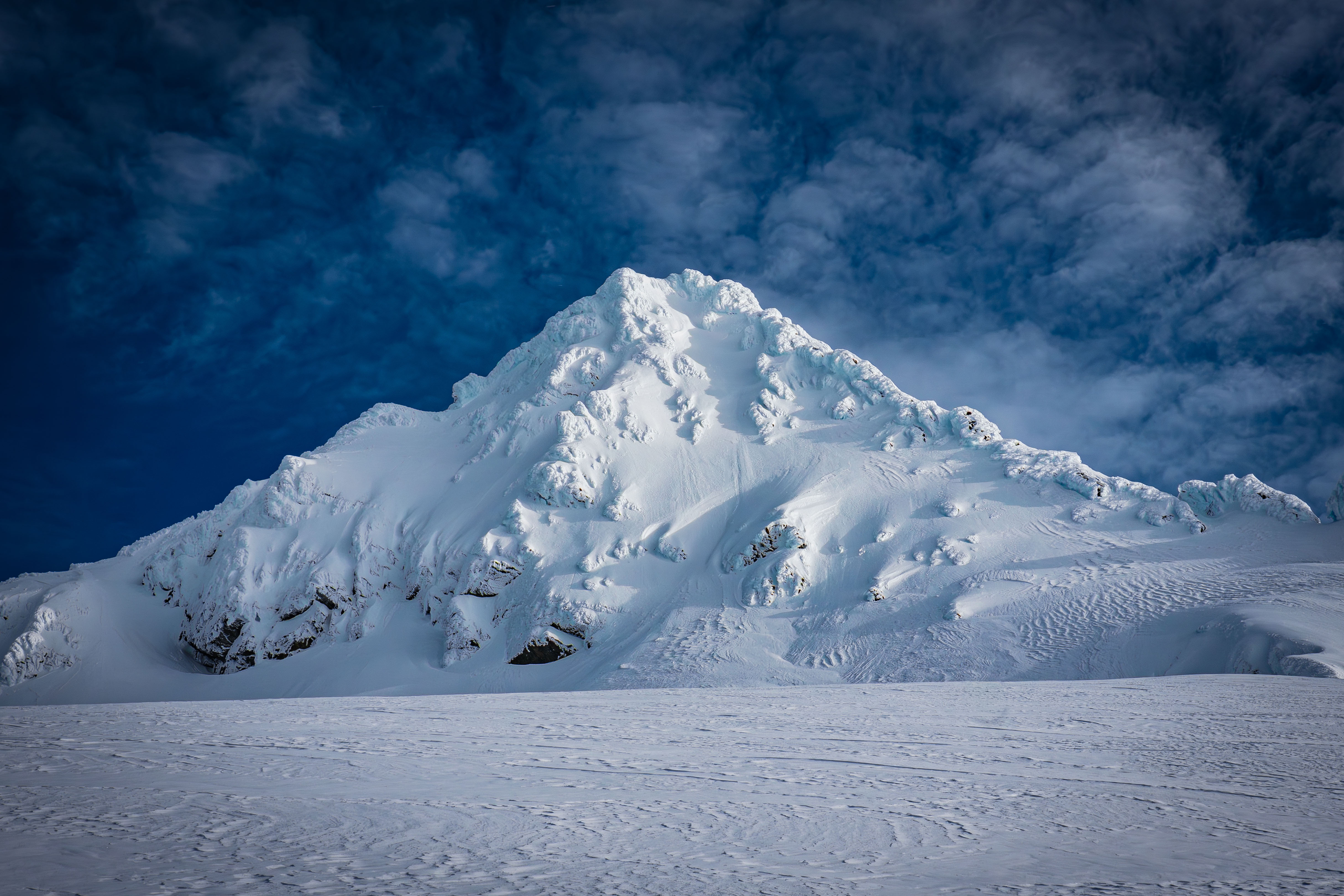
Looking up at Shuksan from the White Salmon Valley

Looking up the White Salmon Glacier

Skinning up the nicely set skin track on the White Salmon

The line we skied down from camp the next day is right next to the cliffs in this photo; it was a much more direct line than where the skier is skiing down in this photo. Winnies Slide is the steep part at the top of the line

Skiers near the top of the White Salmon

Lots of lines near the top of the White Salmon

They could've skinned up that

Almost to Winnies Slide; the summit of Shuksan is in the centre

Above Winnies Slide looking around for the best camping spot

Looking over at Hell's Highway — the obvious saddle to the left

View of Baker from our camp
We started the next day around 6:30; we were the first to break track on the Upper Curtis. We roped up, put on pons, and pulled out axes. The first part was a little exposed and quite icy. Once we got to the rim, we transitioned back to skinning. This wasn't a great call, as just above the rim it was dust on crust. We did very small switchbacks right on the edge, which worked out fine.

Looking up the Upper Curtis from the day prior; the rim is apparent in the centre of the photo

Looking down from the rim on the Upper Curtis
We lost about 200' vert getting over to Hell's Highway due to a large snow berm that ran up to 7600'. The Upper Curtis didn't have a lot of crevasse concerns. Skinning up Hell's Highway was easy without ski pons, even with the rope being annoying.

Skinning up Hell's Highway
After getting to the top of Hell's Highway at 7950’, the terrain flattened and we got on the Sulphide Glacier. The Sulphide was also quite crevasse free, but we still stayed roped till the base of the summit pyramid.

Finally out of the steep Hell's Highway

Looking down the Sulphide, which is also the summer route; doesn't look like a good ski
The summit pyramid covered in winter snow and rime
We decided to go to the ramp to the right instead of ascending the gully directly as we hoped to be able to skin farther. The snow on the summit pyramid was significantly icier than the Sulphide, so we decided not to try to skin farther. We un-roped and brought one of the two ropes up with us. My partner left their skis at the base around 8400', while I carried mine to just above 8600' before deciding to leave them. My partner didn't want to go past 8650' due to icy conditions, so I ascended to summit solo.

Looking out from the pyramid around 8500'

My partner just about to 8650' where they stopped; I was setting down my skis
To climb I used aluminium pons on my ski boots, one axe, and a pole (unsurprisingly the pole didn't help, shocker). Boot purchase ranged from the length of my front points to almost my whole foot in sections. The typical was about half of my boot after several sharp kicks. A fall almost anywhere would've definitely been lethal, or at least a serious injury; arresting seemed unlikely. The gully was on average 45 degrees, ranging from 43-48 or so. The crux was obtaining the summit ridge, which was a small slot through the ice that was around 50-55 degrees. Boot purchase was good there which made it easier, the only problem was kicking all the snow off the ice below. Finding footholds with good purchase was difficult, but it didn't take many to get on the ridge. Once on the ridge, it was only like 30' vert to obtain the summit, and it was just steep walking.

On the very snowy & icy summit

Looking down upon the Sulphide from the summit
Cool little summit, but the clouds rolled in right when I got there. I considered rapping the crux, but it didn't seem worth the gear waste. Surprisingly, with my boot pack, down climbing the crux was easier than the up. Some sections of my boot pack had disappeared due to wind drifting, but going down was generally easier, however no faster. My GPS says it was only 1h 25m to go up and down from my skis at 8600', but that seems short.

Me downclimbing from the summit; my skis are visible in frame

My approximate route up the pyramid
Once I got back to my skis, the clouds had taken over and visibility wasn’t great. It started snowing just before I went down, making visibility even worse. I boarded directly down a chute from above 8600’ to my partner at 8300’. I kept my axe out, but the snow wasn’t as icy down that chute as it was on the ramp or the gully. Chill angle, only around 40-45 degrees till 8400’.
We were mostly blind till Hell’s Highway, but it was good snow down the Sulphide. Vis got better at the Highway and the skiing was great down the whole thing from 7950’ to 7300’. We then skinned back up the Upper Curtis and skied down to camp. The snow was occasionally good, but the exposure was high and the fear of ice beneath the surface made skiing slow and scary. I hit a large ice patch around 7200’ and slid for about 30’ vert before my edge got grip again; should’ve had my axe for that.

Skiing at the bottom of Hell's Highway

The falling snow was starting to get in the way of my lens
It was above freezing at camp and was starting to snow much harder. We took the direct gully down the White Salmon. The snow was fine at the top, but it got increasingly heavy as we descended. Around 4800’ it was more slush-like than powder. The snow started getting very sticky around 3800’ at the turn off to ski the open section. It was too sticky to get good skiing off other’s tracks. We skied down to 2900’ where the large creek is.

Looking back up at the White Salmon, we couldn't even see very far back up our run. Can you spot my partner?

Our route up and down the White Salmon; the track to the left is the gully we skied down
We A-framed back up to the road at 3800’ following a boot pack through the forest. Was worth it to tele (or ski) down the road.

A-framing back up to the road with some day tourers. Was horrid, wet bushwacking up a steep slope